The East West Connector (EWC)
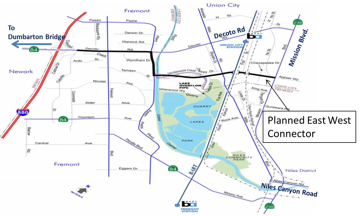
The East West Connector in Union City and Fremont is a new highway that will be constructed between Mission Blvd and Paseo Padre Parkway. It will run through residential neighborhoods and over land that currently consists of a community farm and a pristine riparian wildlife habitat. Approximately 3,000 new housing units are expected to be built along the new road. The East West Connector (EWC) is promoted as a new connector from Mission Blvd to I-880, although significant portions of it utilize the existing Decoto Rd connector. In early 2017, the projected cost was updated from $230M to $320M. The EWC is part of an attempt to build out Mission Blvd as an I-880 bypass and convert Niles Canyon into a high speed shortcut to I-680. The project is planned by the Alameda County Transportation Commission (ACTC), but will be executed by Caltrans.
The sections below provide more information on the four segments making up the EWC. Our webpage also provides information on the devastating impacts on our communities and the shortcomings of this project that will make it largely ineffective.
History of the EWC
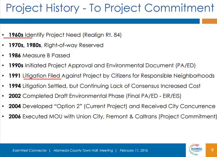
The EWC was first proposed in the 1960s when the Tri-City area was mostly unpopulated. Nevertheless, the EWC has been delayed for 56 years due to fierce opposition from residents and funding shortfalls. In 2014, the East West Connector was quietly added to the expenditure plan of Measure BB. Measure BB made Alameda County the highest sales tax county in the nation, but was approved by voters largely because they were told that Measure BB stood for “Better Buses” and “Better Bikes”. We have not seen better buses yet, but planning of the East West Connector highway was instantly restarted after Measure BB passed. Planning for segments A and D is now already 95% complete and for segments B and C it is 65% complete. Local residents and especially those living in close proximity of the planned roadway were (and still are) mostly kept in the dark.
Segments of the EWC
The sections below provide more information on the four segments that make up the EWC.
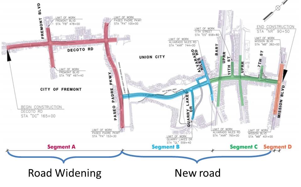
Segment D
Segment D consists of “improvements” to Mission Blvd to provide better access to the EWC from both the North and South facing directions of Mission Blvd. In other words, Mission Blvd. will be widened to include extra turn lanes that can funnel more traffic into Segment C.
Segment C
Segment C is a new 4 to 6 lane highway section that will be built along the Northwest borders of the Park Ridge and Pacific Point Neighborhoods and the Southeast borders of Ashford Place and Monte Vista. The part of segment C feeding onto Mission Blvd will be 6 lanes wide, the rest will be 4 lanes. Segment C is less than 100 ft from family homes on South Cascade Circle, Sandburg Drive, Platinum Street and Monterra Circle. Since it connects busy Mission Blvd with busy Alvarado Niles Rd and has multiple traffic lights along its path, Segment C will likely resemble a parking lot during both the morning and evening commutes.
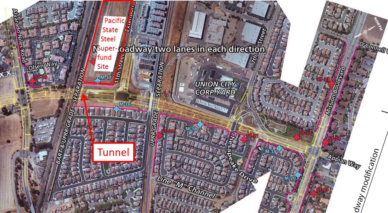
Segment C will also tunnel under two sets of railroad tracks. On the Western end, the tunnel will come within close proximity of both the Pacific State Steel superfund site and the Niles Cone groundwater basin. A bad place to dig a tunnel. The superfund site contains 23,000 cubic yard of contaminated soil that was accumulated under a cap during a 2003 clean up project. The soil under the cap is contaminated with petroleum hydrocarbons, cadmium, chromium and other exciting substances. Can one safely build a tunnel coming within feet of both groundwater and contaminated soil, without contaminating our groundwater? Probably. But unfortunately, our recent experience with corroded steel rods in the $6.4 billion bay bridge show that mistakes can happen at Caltrans, even if crucial to safety (link). Can the water district catch any contamination of our ground water in time? Probably. But as we learned from Flint, MI sometimes they do not. Do we want to take this risk?
Sadly, the neighborhoods mentioned here would benefit from access to Alvarado Niles Road as many of its residents have to head West in the morning. Currently, these residents have to take the detour via Mission Blvd to get onto West-bound Decoto Rd. These neighborhoods should have been built with a residential road that links to Alvarado Niles. But having the foresight to preempt opposition of these residents to a highway right outside their windows, planners chose to landlock these neighborhoods, placing them between a rock and a hard place: Large highway or no access at all.
We believe that is not right. Instead of a 4-6 lane highway, a residential two lane road (one lane in each direction) should be built as an extension of 7th street. This road should include standard traffic calming measures, such as speed bumps and chicanes to dissuade through traffic. Instead of widening Mission Blvd to invite through traffic, peak hour turn restrictions should protect residents from through traffic. Any road that is constructed in such proximity to family homes should be built to the benefit of the adjoining neighborhoods. The opposite is the case right now. A narrower one lane road would also allow for larger clearance from the superfund site and the addition of a Class I bike path.
Segment B
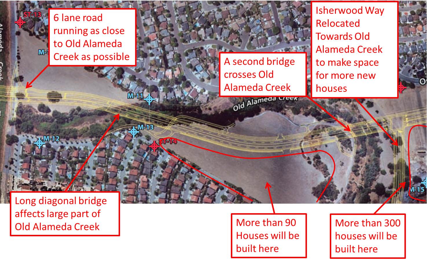
Segment B is perhaps the most damaging to our environment and charm of our area. It will require the eviction of the Ramirez farm, a popular pesticide free community farm. The farm land that will be taken up by the road has already been rezoned for high density housing and approximately 300 houses are planned there. Making space for these houses also means that Isherwood Way will be realigned to hug the Eastern portion of the Old Alameda Creek riparian wildlife habitat. A large intersection facilitates sending traffic down Isherwood Way, bringing much traffic to the 40+ homes on the South Eastern end of Mission Lakes along Harrisburg Avenue. Segment B then proceeds across the pristine Old Alameda Creek via a four lane highway bridge. On the Southern side of Segment B, at least 90 more houses will be built. West of this new neighborhood, Segment B will diagonally cross the Old Alameda Creek for a second time. The diagonal crossing substantially increases the amount of creek land that will be impacted by the bridge. At this location, the 4 lane highway also comes within close proximity of many family homes on both the Union City and Fremont sides. After this crossing, Segment B will undergo a slight bend to hug the Old Alameda Creek, perhaps to maximize the space North of it available for future housing projects. Segment B will then widen to six lanes and feed into a newly constructed bridge across the Alameda Creek Channel, forcing bicyclists and hikers on the popular Alameda Creek Trail down a narrow underpath. The bridge then intersects Paseo Padre to form a giant 12 lane intersection. This monstrous intersection will be right in-between Mission Lakes with its 294 homes and the new school that will be constructed on the other side of Paseo Padre, virtually ensuring that every sane parent will drive their kids to school, rather than letting them walk or bike, forcing more people into their cars and inducing more traffic.
Segment A
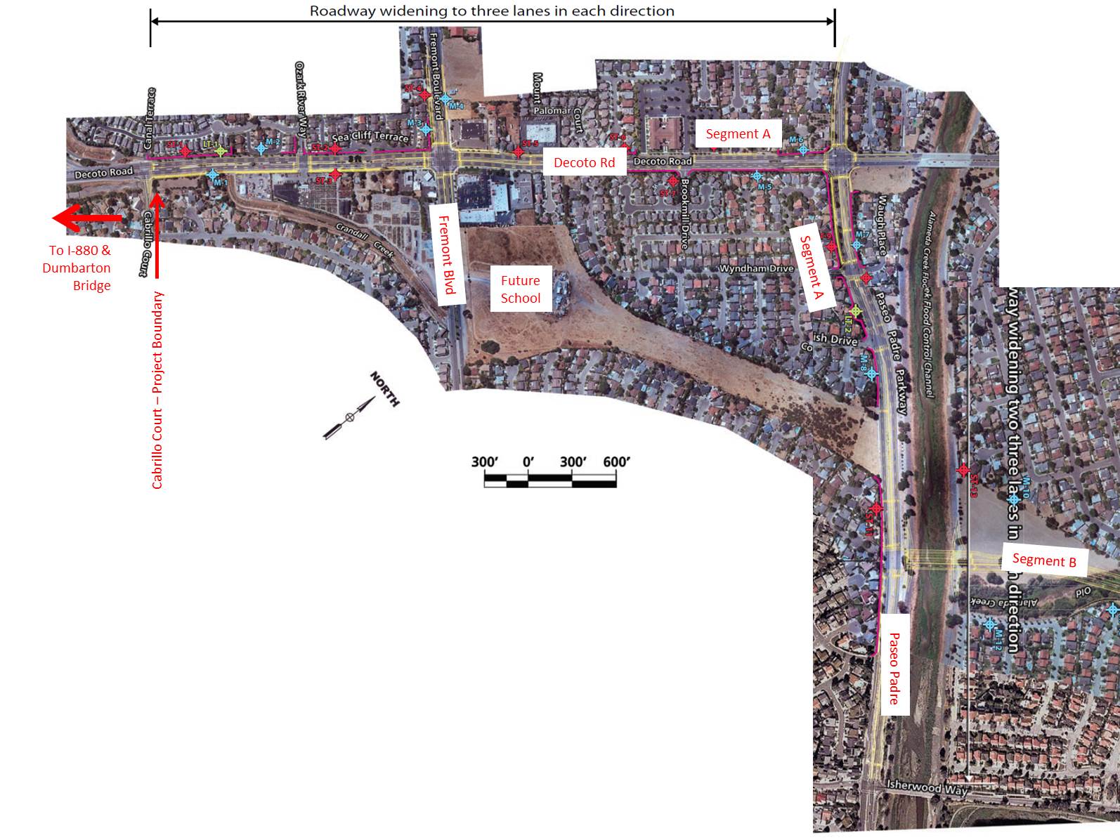
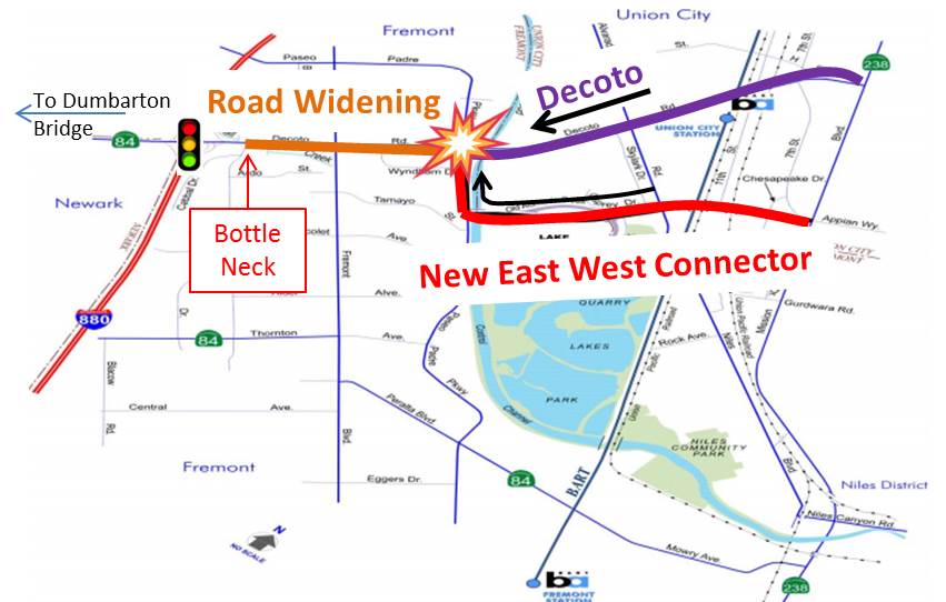
Segment A does not consist of new road construction. Instead it is based on existing Paseo Padre Parkway and Decoto Rd. Although the EWC is promoted as a new connection between Mission Blvd and I-880, the East West Connector really only links Mission Blvd to Paseo Padre Pkwy. Paseo Padre in turn intersects with existing Decoto Rd. In the morning, it thus feeds the newly induced traffic onto already congested Decoto Road. The Alameda County Transportation Commission (ACTC) claims that increased congestion on Decoto will be managed by widening Paseo Padre and Decoto Rd to 3 lanes. Unfortunately, three severe problems exist with this approach:
- Westbound Decoto Rd feeds onto the Dumbarton Bridge and that is where the overwhelming majority of Decoto traffic is headed in the morning. On its way to the bridge, Decoto Rd crosses I-880 and requires two traffic lights to allow massive amounts of bridge bound traffic from I-880 to merge onto it. These two traffic lights are THE prime cause for severe backups on Decoto, which often can extend all the way to Paseo Padre and beyond. The East West Connector leaves this bottleneck completely unchanged and instead piles more traffic into it.
- The Western project boundary of the EWC is Cabrillo Rd. In other words, the project ends one intersection short of connecting to I-880. That means, the East West Connector will NOT widen Decoto Rd between Cabrillo and I-880. So not only do the traffic lights at the intersection of Decoto and I-880 cause the primary backup on Decoto Rd, but traffic will have to continue to merge from 3 lanes to two lanes at this most congested location.
- Decoto Rd is already three lanes at most locations, except at the most upstream end between Paseo Padre Pkwy and Fremont Blvd. The reason for widening this upstream section to three lanes therefore cannot be to improve flow. This is impossible since the downstream bottle neck remains in place. The true reason for widening the most upstream portion of Decoto Rd is to pool incoming traffic that has nowhere to go. The same is the case for Paseo Padre, which needs to pool traffic that is coming from Segment C and needs to wait at the traffic light to turn onto Decoto.
Complete traffic gridlock for West bound traffic in the morning is thus already pre-programmed. While the bottle neck is not removed, more traffic is piled into it at a faster rate. In other words, ACTC is essentially widening the cone of the funnel to accept more traffic while leaving the stem as narrow as it was before. This will have disastrous consequences for the morning commute.
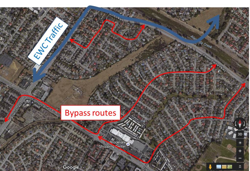
In the evening commute, the situation will be little better. Today, with most traffic going straight on Decoto Rd, the right turn lane onto Paseo Padre is generally not very congested. This keeps cars wanting to turn South onto Paseo Padre from cutting through Brookvale-Nicolet. Once the EWC is in place, the right turn lane on Decoto Rd. will also be heavily congested. Those drivers that want to bypass traffic on the EWC are therefore likely to cut through Wyndham, Tamayo Street and Nicolet Ave/Isherwood Way, bringing large amounts of traffic to residential neighborhoods.